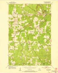
1954 Map of South Range
USGS Topo · Published 1955About this map
Amnicon River and its various tributaries define this Douglas County landscape, where the waters of the Little Amnicon River, Silver Creek, and Middle River carve through the terrain. The presence of the Middle River Sanatorium near the community of Hines reflects the social infrastructure of the mid-1950s. Settlement patterns are closely tied to the extensive rail network, with lines like the Chicago and North Western Railway, Northern Pacific, and Minneapolis St Paul and Sault Ste Marie Railroad intersecting near South Range and Rockmont. The map also captures specialized land uses, from the Rifle Range in the northwest to the Flanagan Lookout Tower and various Gravel Pits that indicate local industrial activity during this period.
Find a feature on this map
27 named features on this map. Tap any name to fly to it.
Don’t see what you’re looking for? This feature index may not catch every label — zoom into the map to look around manually.
Map Details
Editions of this 1954 South Range Map
2 editions found
Other maps of this area

1915 · Superior
USGS Topo · 1:48,000

1917 · Superior
USGS Topo · 1:62,500

1945 · Solon Springs
USGS Topo · 1:48,000

1949 · Solon Springs
USGS Topo · 1:48,000

1949 · Patzau
USGS Topo · 1:48,000

1949 · Poplar
USGS Topo · 1:48,000

1953 · Ashland
USGS Topo · 1:250,000

1953 · Duluth
USGS Topo · 1:250,000

1954 · Sunnyside
USGS Topo · 1:24,000
1954 · Superior
USGS Topo · 1:24,000