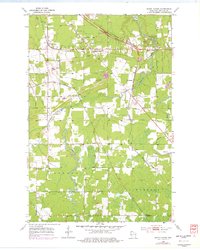
1954 Map of South Range
USGS Topo · Published 1977About this map
Amnicon River and its tributaries carve through this Douglas County landscape, punctuated by the dramatic cascades of Amnicon Falls State Park. The map reveals a mid-century transportation corridor where the Burlington Northern and the Soo Line railroads intersect the rural terrain near South Range. This 1954 survey, updated with 1975 photorevisions, captures the industrial and institutional footprint of the era, including several Gravel Pits and the Middle River Sanatorium located near Hines. Small community focal points like Oakland Ch and the Flannagan Lookout Tower provide specific touchpoints for local historians. The presence of a Rifle Range and a Weigh Station along the highway indicates the functional, utilitarian development of the Northwoods during this period of growth.
Find a feature on this map
29 named features on this map. Tap any name to fly to it.
Don’t see what you’re looking for? This feature index may not catch every label — zoom into the map to look around manually.
Map Details
Editions of this 1954 South Range Map
2 editions found
Other maps of this area

1915 · Superior
USGS Topo · 1:48,000

1917 · Superior
USGS Topo · 1:62,500

1945 · Solon Springs
USGS Topo · 1:48,000

1949 · Solon Springs
USGS Topo · 1:48,000

1949 · Patzau
USGS Topo · 1:48,000

1949 · Poplar
USGS Topo · 1:48,000

1953 · Ashland
USGS Topo · 1:250,000

1953 · Duluth
USGS Topo · 1:250,000

1954 · Sunnyside
USGS Topo · 1:24,000
1954 · Superior
USGS Topo · 1:24,000