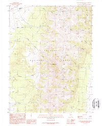
1988 Map of South Shoshone Peak
USGS Topo · Published 1988About this map
Toiyabe National Forest encompasses this high-altitude basin where the border of Lander and Nye Counties follows the high ridges. The landscape is defined by the steep drainage systems of the Shoshone Mountains, where water flows through corridors like Waterfall Canyon, Bonita Canyon, and Sawmill Canyon toward the Ione Wash. Near the northern boundary, the presence of an Adit, Mine Shaft, and various Prospects indicate the historic mineral exploration that shaped this region's early development.
Find a feature on this map
22 named features on this map. Tap any name to fly to it.
Don’t see what you’re looking for? This feature index may not catch every label — zoom into the map to look around manually.
Map Details
Editions of this 1988 South Shoshone Peak Map
This is the sole edition of this map. No revisions or reprints were ever made.
Other maps of this area

1907 · Tonopah
USGS Topo · 1:250,000

1908 · Tonopah
USGS Topo · 1:250,000

1948 · Ione
USGS Topo · 1:62,500

1950 · Ione
USGS Topo · 1:62,500

1955 · Millett
USGS Topo · 1:250,000

1956 · South Shoshone Peak
USGS Topo · 1:62,500

1956 · North Shoshone Peak
USGS Topo · 1:62,500

1956 · Tonopah
USGS Topo · 1:250,000

1959 · Tonopah
USGS Topo · 1:250,000

1959 · Millett
USGS Topo · 1:250,000