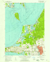
1956 Map of Southampton
USGS Topo · Published 1957About this map
Southampton and its surrounding hamlets show a landscape defined by coastal luxury and indigenous heritage during the mid-1950s. The village core is densely detailed, featuring landmarks such as St Johns Ch, the Old Southampton Cem, and the village Hospital. To the west, the expansive Shinnecock Indian Reservation sits between the Long Island RR and the waters of Shinnecock Bay, while the northern reaches include the isolated Robins Island and the oyster-rich waters of Little Peconic Bay. The area's identity as a premier recreation destination is evident in the cluster of world-class grounds like the National Golf Links of America and Shinnecock Hills Golf Course, alongside the North Fork Country Club across the water in New Suffolk. Inland, smaller communities like Art Village and Tuckahoe are connected by a network of historic lanes such as Majors Path and Captain Neck Lane.
Find a feature on this map
68 named features on this map. Tap any name to fly to it.
Don’t see what you’re looking for? This feature index may not catch every label — zoom into the map to look around manually.
Map Details
Editions of this 1956 Southampton Map
2 editions found
Other maps of this area

1903 · Sag Harbor
USGS Topo · 1:62,500

1903 · Riverhead
USGS Topo · 1:62,500

1904 · Sag Harbor
USGS Topo · 1:62,500

1904 · Shelter Island
USGS Topo · 1:62,500

1904 · Riverhead
USGS Topo · 1:62,500

1943 · Riverhead
USGS Topo · 1:62,500

1946 · Sag Harbor
USGS Topo · 1:24,000

1947 · Mattituck
USGS Topo · 1:24,000

1947 · Mattituck Hills
USGS Topo · 1:24,000

1947 · Southold
USGS Topo · 1:24,000