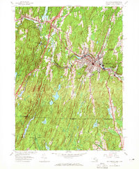
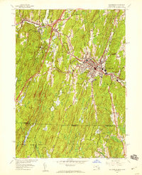
1952 Map of Southbridge
USGS Topo · Published 1965About this map
Southbridge serves as the industrial and population hub of this Massachusetts-Connecticut borderland, centered on the winding Quinebaug River. The survey captures a moment of transition where established mill settlements like Globe Village and Sandersdale meet the emerging mid-century highway system, notably the Mass Tpk (Interchange 9). Cultural and historical landmarks are prominently featured, including the living history site at Old Sturbridge Village and the recreational Robinson Crusoe Camp. To the south, the landscape shifts toward the dense woodlands of Nipmuck State Forest, which straddles the state line. This area is defined by its complex water management system, visible through a series of numbered reservoirs such as No 3 Reservoir and No 4 Reservoir, alongside numerous family-named bodies of water like Wells Pond and Prindle Pond.
Find a feature on this map
50 named features on this map. Tap any name to fly to it.
Don’t see what you’re looking for? This feature index may not catch every label — zoom into the map to look around manually.
Map Details
Editions of this 1952 Southbridge Map
5 editions found
Other maps of this area

1887 · Brookfield
USGS Topo · 1:62,500

1889 · Webster
USGS Topo · 1:62,500

1889 · Putnam
USGS Topo · 1:62,500

1890 · Brookfield
USGS Topo · 1:62,500

1892 · Woodstock
USGS Topo · 1:62,500

1892 · Webster
USGS Topo · 1:62,500

1893 · Putnam
USGS Topo · 1:62,500

1893 · Brookfield
USGS Topo · 1:62,500

1908 · Quinsigamond
USGS Topo · 1:125,000

1908 · Ware
USGS Topo · 1:125,000