1953 Map of Southbury
USGS Topo · Published 1959About this map
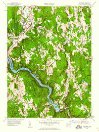
The Housatonic River and its massive expansion into Lake Zoar dominate this mid-century portrait of New Haven and Fairfield counties. The landscape transitions from the developed corridors of Southbury and South Britain in the north toward the recreation-focused terrain along the river banks. Landmarks such as the South Britain Consolidated Sch and St Thomas Ch anchor the older residential nodes, while the presence of Southford Falls State Park and Kettletown State Park reflects the post-war emphasis on public outdoor space. The industrial past is still visible in labels like Paper Mill Pond and a local Mine, while agricultural roots persist in named hilltops such as Georges Hill and Osborn Hill. Extensive road networks, including Poverty Hollow Road and Bullet Hill Road, connect the scattered hamlets of Southford, Quaker Farms, and Lakeside.
Find a feature on this map
58 named features on this map. Tap any name to fly to it.
Don’t see what you’re looking for? This feature index may not catch every label — zoom into the map to look around manually.
Map Details
Editions of this 1953 Southbury Map
3 editions found


Other maps of this area

1889 · Derby
USGS Topo · 1:62,500

1891 · Derby
USGS Topo · 1:62,500

1892 · Danbury
USGS Topo · 1:62,500

1892 · New Milford
USGS Topo · 1:62,500

1893 · Waterbury
USGS Topo · 1:62,500

1893 · New Milford
USGS Topo · 1:62,500

1893 · Derby
USGS Topo · 1:62,500

1904 · New Milford
USGS Topo · 1:62,500

1904 · Waterbury
USGS Topo · 1:62,500

1904 · Litchfield
USGS Topo · 1:125,000