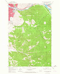
1964 Map of Southeast Missoula
USGS Topo · Published 1967About this map
The University of Montana campus anchors the northwest corner of this 1964 survey, showing the institution's mid-century footprint alongside Dornblaser Field and the University Golf Course. This view documents the southern expansion of Missoula at the foot of Mount Sentinel, where the University Beacon and Radio Tower overlook the confluence of the Clark Fork and Blackfoot R. The map details a vital industrial and transit corridor where the Northern Pacific and Chicago Milwaukee St Paul and Pacific railroads parallel the river.
Find a feature on this map
58 named features on this map. Tap any name to fly to it.
Don’t see what you’re looking for? This feature index may not catch every label — zoom into the map to look around manually.
Map Details
Editions of this 1964 Southeast Missoula Map
3 editions found
Other maps of this area

1903 · Bonner
USGS Topo · 1:125,000

1912 · Missoula
USGS Topo · 1:125,000

1947 · Butte
USGS Topo · 1:250,000

1956 · Hamilton
USGS Topo · 1:250,000

1958 · Butte
USGS Topo · 1:250,000

1959 · Hamilton
USGS Topo · 1:250,000

1959 · Cleveland Mountain
USGS Topo · 1:62,500

1960 · Butte
USGS Topo · 1:250,000

1960 · Hamilton
USGS Topo · 1:250,000

1962 · Butte
USGS Topo · 1:250,000