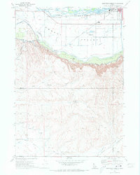
1970 Map of Southwest Emmett
USGS Topo · Published 1973About this map
Payette River waters dominate the northern landscape of this survey, where a complex network of irrigation infrastructure supports the Emmett Valley agriculture. This system includes the Farmers Cooperative Canal, Reed Canal, and the Last Chance Canal, which transition from the river basin toward the dramatic elevation change of Black Canyon and the Freezeout hills. These physical barriers separate the fertile valley floor from the dissected plateau of Hartley Gulch to the south.
Find a feature on this map
40 named features on this map. Tap any name to fly to it.
Don’t see what you’re looking for? This feature index may not catch every label — zoom into the map to look around manually.
Map Details
Editions of this 1970 Southwest Emmett Map
This is the sole edition of this map. No revisions or reprints were ever made.
Other maps of this area

1892 · Boise
USGS Topo · 1:125,000

1897 · Boise
USGS Topo · 1:125,000

1898 · Nampa
USGS Topo · 1:125,000

1953 · Star
USGS Topo · 1:24,000

1953 · Montour
USGS Topo · 1:62,500

1955 · Boise
USGS Topo · 1:250,000

1958 · Boise
USGS Topo · 1:250,000
1958 · Middleton
USGS Topo · 1:24,000
1958 · Caldwell
USGS Topo · 1:24,000

1962 · Boise
USGS Topo · 1:250,000