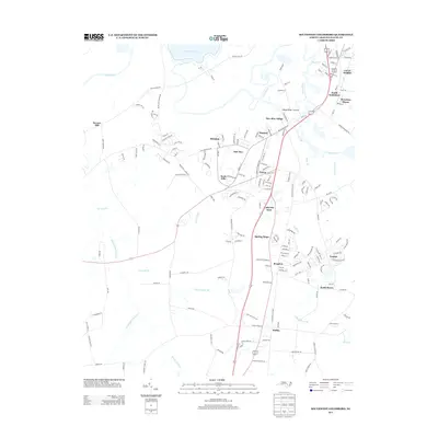
2013 Map of Southwest Goldsboro
USGS Topo · Published 2013About this map
The Neuse River snakes through the landscape south of the city, defining the geography of Wayne County during this early 21st-century period. The river is characterized by complex hydrography, including the Neuse River Cut-Off and numerous low-lying drainages like Thoroughfare Swamp and Yellow Marsh Br. Residential development is concentrated in suburban clusters such as Mar-Mac Village, Lafayette Park, and Brogden, showing the transition from rural agricultural land to organized neighborhoods. To the northwest, Stevens Mill stands as a testament to the area's milling history, while the northern edge touches the outskirts of South Goldsboro and Carver Heights. This survey captures the region's character as it balances established rural landmarks with modern growth, visible in the network of smaller settlements like Dudley and Scott Hills that are linked by local roads such as Stevens Mill Rd and Old Grantham Rd.
Find a feature on this map
171 named features on this map. Tap any name to fly to it.
Don’t see what you’re looking for? This feature index may not catch every label — zoom into the map to look around manually.
Map Details
Editions of this 2013 Southwest Goldsboro Map
This is the sole edition of this map. No revisions or reprints were ever made.
Other maps of this area

1953 · Rocky Mount
USGS Topo · 1:250,000

1953 · Raleigh
USGS Topo · 1:250,000

1954 · Rocky Mount
USGS Topo · 1:250,000

1954 · Raleigh
USGS Topo · 1:250,000

1957 · Goldsboro
USGS Topo · 1:62,500

1957 · Seven Springs
USGS Topo · 1:62,500

1974 · Grantham
USGS Topo · 1:24,000

1974 · Northwest Goldsboro
USGS Topo · 1:24,000
1974 · Princeton
USGS Topo · 1:24,000

1974 · Southwest Goldsboro
USGS Topo · 1:24,000