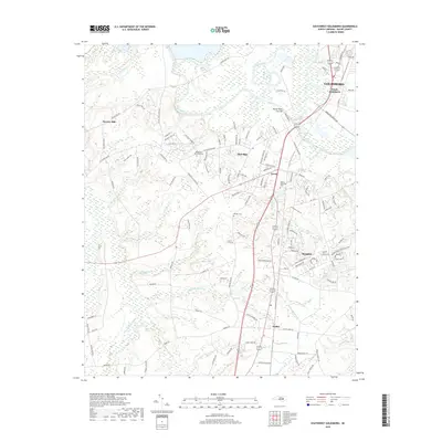
2019 Map of Southwest Goldsboro
USGS Topo · Published 2019About this map
Goldsboro and its southern neighboring communities are defined by the winding course of the Neuse River, which dominates the northern landscape of this survey. The hydrology of Wayne County is particularly prominent here, showing the intricate network of the Neuse River Cut-Off, Thoroughfare Swamp, and Brooks Swamp as they drain the coastal plain. Historically significant landmarks include Rhodes Cem and the large burial grounds of Wayne Memorial Park and Resthaven Memorial Park. The map documents a blend of established settlements like Dudley and Brogden alongside newer residential corridors. To the west, the landscape transitions into more rural terrain near Henry's Hill and the community of Stevens Mill. This 2019 edition provides a detailed perspective on the transportation infrastructure and local hydrology that has shaped the growth of the region south of the city center.
Find a feature on this map
123 named features on this map. Tap any name to fly to it.
Don’t see what you’re looking for? This feature index may not catch every label — zoom into the map to look around manually.
Map Details
Editions of this 2019 Southwest Goldsboro Map
This is the sole edition of this map. No revisions or reprints were ever made.
Other maps of this area

1953 · Rocky Mount
USGS Topo · 1:250,000

1953 · Raleigh
USGS Topo · 1:250,000

1954 · Rocky Mount
USGS Topo · 1:250,000

1954 · Raleigh
USGS Topo · 1:250,000

1957 · Goldsboro
USGS Topo · 1:62,500

1957 · Seven Springs
USGS Topo · 1:62,500

1974 · Grantham
USGS Topo · 1:24,000

1974 · Northwest Goldsboro
USGS Topo · 1:24,000
1974 · Princeton
USGS Topo · 1:24,000

1974 · Southwest Goldsboro
USGS Topo · 1:24,000