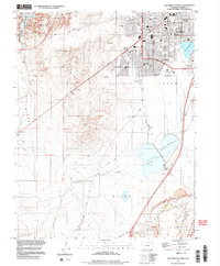
1998 Map of Southwest Pueblo
USGS Topo · Published 1999About this map
Pueblo expands south and west in the late 1990s, anchored by the State Fairgrounds and an extensive network of neighborhood schools and parks. The urban landscape is defined by its institutional and recreational hubs, including Mountain View Cemetery, the Sangre de Cristo Parish, and several educational landmarks like South High Sch and Corwin Middle Sch. To the west, the arid terrain of Boggs Flat and the drainage of Boggs Creek lead toward Lake Pueblo State Park, while the city’s industrial and agricultural history is visible through the Aqueduct system and an Old Railroad Grade cutting across the southern plains.
Find a feature on this map
63 named features on this map. Tap any name to fly to it.
Don’t see what you’re looking for? This feature index may not catch every label — zoom into the map to look around manually.
Map Details
Editions of this 1998 Southwest Pueblo Map
2 editions found
Other maps of this area

1891 · Pueblo
USGS Topo · 1:125,000

1894 · Pueblo
USGS Topo · 1:125,000

1896 · Pueblo
USGS Topo · 1:125,000

1897 · Pueblo
USGS Topo · 1:125,000

1954 · Pueblo
USGS Topo · 1:250,000

1957 · Pueblo
USGS Topo · 1:250,000

1958 · Pueblo
USGS Topo · 1:250,000

1960 · Southeast Pueblo
USGS Topo · 1:24,000

1961 · Northwest Pueblo
USGS Topo · 1:24,000

1961 · Southwest Pueblo
USGS Topo · 1:24,000