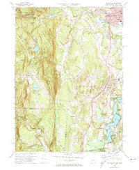
1972 Map of Southwick
USGS Topo · Published 1974About this map
The Congamond Lakes anchor the southeastern corner of this study, marking a distinct chain of water bodies where North Pond, Middle Pond, and South Pond straddle the Massachusetts-Connecticut border. To the west, the landscape rises sharply toward Drake Mountain and Sodom Mountain, which includes the Sodom Mtn Ski Area. The transition from the rugged highlands of Granville to the flatter plains of Southwick is reflected in the land use, shifting from protected lands like the Tunxis State Forest to more developed infrastructure around Westfield.
Find a feature on this map
109 named features on this map. Tap any name to fly to it.
Don’t see what you’re looking for? This feature index may not catch every label — zoom into the map to look around manually.
Map Details
Editions of this 1972 Southwick Map
4 editions found
Other maps of this area

1886 · Springfield
USGS Topo · 1:62,500

1887 · Granville
USGS Topo · 1:62,500

1889 · Springfield
USGS Topo · 1:62,500

1889 · Granville
USGS Topo · 1:62,500

1892 · Hartford
USGS Topo · 1:62,500

1892 · Granby
USGS Topo · 1:62,500

1893 · Springfield
USGS Topo · 1:62,500

1893 · Granville
USGS Topo · 1:62,500

1895 · Springfield
USGS Topo · 1:62,500

1895 · Granville
USGS Topo · 1:62,500