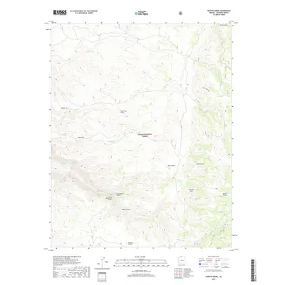
2018 Map of Sowats Spring
USGS Topo · Published 2018About this map
Kaibab National Forest encompasses this high-altitude landscape on the Kaibab Plateau, where water management and topographical landmarks define the territory. The intricate drainage network of Sowats Canyon, Big Sowats Canyon, and Little Sowats Canyon dominates the southern half of the sheet, providing a clear picture of the erosive forces shaping the region. Historically significant water sources like Sowats Spring and Box Elder Spring are noted alongside man-made improvements such as White Pockets Tank and Bone Hollow Tank, illustrating the essential infrastructure for ranching or forestry in an arid environment. High points including Brow Monument and Sawmill Point offer orientation across the complex terrain, while designated crossings like Eagle Pass and Ranger Pass indicate established routes through the breaks.
Find a feature on this map
25 named features on this map. Tap any name to fly to it.
Don’t see what you’re looking for? This feature index may not catch every label — zoom into the map to look around manually.
Map Details
Editions of this 2018 Sowats Spring Map
This is the sole edition of this map. No revisions or reprints were ever made.
Other maps of this area

1886 · Kaibab
USGS Topo · 1:250,000

1953 · Grand Canyon
USGS Topo · 1:250,000

1957 · Grand Canyon
USGS Topo · 1:250,000

1957 · Jumpup Canyon
USGS Topo · 1:62,500

1958 · Grand Canyon
USGS Topo · 1:250,000

1958 · Big Springs
USGS Topo · 1:62,500

1960 · Grand Canyon
USGS Topo · 1:250,000

1962 · Kanab Point
USGS Topo · 1:62,500
1962 · Powell Plateau
USGS Topo · 1:62,500

1984 · Grand Canyon
USGS Topo · 1:100,000