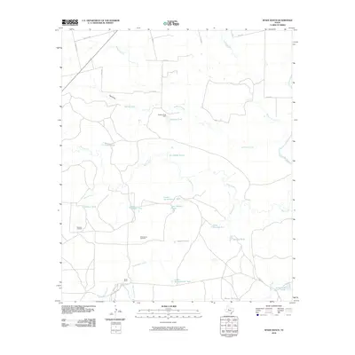
2010 Map of Spade Ranch
USGS Topo · Published 2010About this map
Spade Ranch anchors this portion of Mitchell County, where ranching infrastructure dominates a landscape defined by seasonal water management. The terrain is crisscrossed by numerous named watercourses, including Beals Creek, Wildhorse Creek, and Renderbrook Creek, which feed an extensive system of man-made catchments like the Lower Renderbrook Tank and Geneva Tank. These features, along with specialized landmarks like the Mud Spring Windmill and Wildcat Windmill, reveal the critical importance of water access for livestock in this region of Texas. The presence of the Dockrey Tank Dam and various numbered tanks suggests a highly engineered approach to rangeland management. Transportation is provided by a network of county roads, such as Ranch Rd 670 and Co Rd 331, while the Colorado River touches the eastern edge of the survey, providing a primary hydrological boundary for the surrounding ranchlands.
Find a feature on this map
37 named features on this map. Tap any name to fly to it.
Don’t see what you’re looking for? This feature index may not catch every label — zoom into the map to look around manually.
Map Details
Editions of this 2010 Spade Ranch Map
This is the sole edition of this map. No revisions or reprints were ever made.
Other maps of this area

1950 · Lake Colorado City
USGS Topo · 1:24,000

1950 · Colorado City SE
USGS Topo · 1:24,000

1952 · Westbrook
USGS Topo · 1:24,000

1954 · Big Spring
USGS Topo · 1:250,000

1958 · Big Spring
USGS Topo · 1:250,000

1959 · Pecan Crossing
USGS Topo · 1:24,000

1959 · Spade Ranch
USGS Topo · 1:24,000

1959 · McWhorter Mountain
USGS Topo · 1:24,000

1959 · Dead Indian Mountain
USGS Topo · 1:24,000

1962 · Hyman NE
USGS Topo · 1:24,000