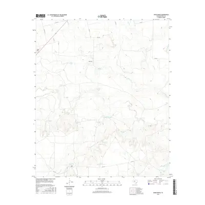
2016 Map of Spade Ranch
USGS Topo · Published 2016About this map
Spade Ranch and its surrounding pastoral landscape define this West Texas territory in Mitchell County. The terrain is marked by a complex network of ephemeral waterways and ranch infrastructure, where drainage systems like Wildhorse Cr and Granger Cr flow toward the Colorado River at the eastern edge. Natural landmarks such as Beals Mtn and Renderbrook Spring provide significant points of orientation in a region traditionally dedicated to large-scale ranching. The map reveals an extensive system of water management essential for livestock, including Lower Renderbrook Tank, Geneva Tank, and the numerically labeled catchments such as Tank Number Two. A grid of county roads, including Co RD 331 and Co RD 353, provides the primary access through this dry landscape, connecting the headquarters at the ranch to its outlying pastures and seasonal creeks like Wildcat Cr.
Find a feature on this map
36 named features on this map. Tap any name to fly to it.
Don’t see what you’re looking for? This feature index may not catch every label — zoom into the map to look around manually.
Map Details
Editions of this 2016 Spade Ranch Map
This is the sole edition of this map. No revisions or reprints were ever made.
Other maps of this area

1950 · Lake Colorado City
USGS Topo · 1:24,000

1950 · Colorado City SE
USGS Topo · 1:24,000

1952 · Westbrook
USGS Topo · 1:24,000

1954 · Big Spring
USGS Topo · 1:250,000

1958 · Big Spring
USGS Topo · 1:250,000

1959 · Pecan Crossing
USGS Topo · 1:24,000

1959 · Spade Ranch
USGS Topo · 1:24,000

1959 · McWhorter Mountain
USGS Topo · 1:24,000

1959 · Dead Indian Mountain
USGS Topo · 1:24,000

1962 · Hyman NE
USGS Topo · 1:24,000