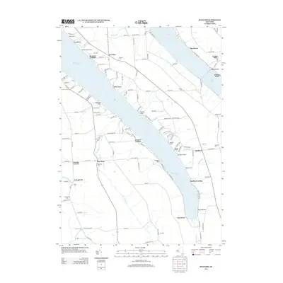
2013 Map of Spafford
USGS Topo · Published 2013About this map
Skaneateles Lake dominates the central landscape of this western Onondaga County region, flanked by steep bluffs and several residential lake-front clusters. Settlements such as Borodino, Spafford, and New Hope serve as the primary inland hubs, while the shoreline is dotted with specific points and landings including Borodino Landing, Gregory Landing, and Spafford Landing. The presence of numerous family and community burial grounds, such as Spafford Cem, James Cem, and Kelloggsville Cem, provides valuable documentation for local genealogists. In the northeast corner, the map also includes a portion of the Lower Basin of Otisco Lake, where communities like Rice Grove and Williams Grove line the water. Natural landmarks such as Carpenter Falls and Barber Gulf illustrate the dramatic elevation changes that characterize the Finger Lakes topography, while Gamble Mill points toward the area's historical industrial processing sites.
Find a feature on this map
137 named features on this map. Tap any name to fly to it.
Don’t see what you’re looking for? This feature index may not catch every label — zoom into the map to look around manually.
Map Details
Editions of this 2013 Spafford Map
This is the sole edition of this map. No revisions or reprints were ever made.
Other maps of this area

1898 · Moravia
USGS Topo · 1:62,500

1899 · Skaneateles
USGS Topo · 1:62,500

1900 · Tully
USGS Topo · 1:62,500

1902 · Skaneateles
USGS Topo · 1:62,500

1902 · Moravia
USGS Topo · 1:62,500

1903 · Cortland
USGS Topo · 1:62,500

1943 · South Onondaga
USGS Topo · 1:31,680

1943 · Moravia
USGS Topo · 1:31,680

1943 · Spafford
USGS Topo · 1:31,680

1943 · Owasco
USGS Topo · 1:31,680