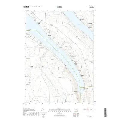
2019 Map of Spafford
USGS Topo · Published 2019About this map
Skaneateles Lake dominates this central New York landscape, carving a deep glacial valley through the Finger Lakes region. Small hamlets like Borodino, New Hope, and Kelloggsville are scattered across the higher elevations, connected by a network of rural roads such as Town Line Rd and Sayles Corners Rd. The map reveals a high density of ancestral sites for genealogists, including the Stanton Family Cem and Lewis Family Cem, alongside established community grounds like the Borodino Cem. Along the eastern shore of the lake, topographical features such as Tenmile Point and Stag Horn Point define the rugged shoreline, while the southern end transitions into the drainage of Grout Brook and the settlement of Glen Haven. In the northeast, the map includes a portion of Otisco Lake and the localized milling history suggested by Gamble Mill.
Find a feature on this map
111 named features on this map. Tap any name to fly to it.
Don’t see what you’re looking for? This feature index may not catch every label — zoom into the map to look around manually.
Map Details
Editions of this 2019 Spafford Map
This is the sole edition of this map. No revisions or reprints were ever made.
Other maps of this area

1898 · Moravia
USGS Topo · 1:62,500

1899 · Skaneateles
USGS Topo · 1:62,500

1900 · Tully
USGS Topo · 1:62,500

1902 · Skaneateles
USGS Topo · 1:62,500

1902 · Moravia
USGS Topo · 1:62,500

1903 · Cortland
USGS Topo · 1:62,500

1943 · South Onondaga
USGS Topo · 1:31,680

1943 · Moravia
USGS Topo · 1:31,680

1943 · Spafford
USGS Topo · 1:31,680

1943 · Owasco
USGS Topo · 1:31,680