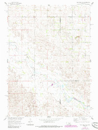
1960 Map of Spalding 2 NE
USGS Topo · Published 1985About this map
Beaver Creek winds through a landscape of shifting prairie dunes and agricultural boundaries at the meeting point of three Nebraska counties. This 1960 survey, updated in the early 1980s, documents a rural network centered around small communal nodes like Park Ch and the nearby Park Center Sch in the northern reach. The topographic detail highlights the unique hydrology of the Sandhills transition, including several instances of a Flowing Well and the presence of School No 3 south of the county line. The map serves as a precise record of the land as it was managed under the Missouri River Basin development program, illustrating the sparsely distributed farmsteads and the critical role of water management in this prairie environment.
Find a feature on this map
8 named features on this map. Tap any name to fly to it.
Don’t see what you’re looking for? This feature index may not catch every label — zoom into the map to look around manually.
Map Details
Editions of this 1960 Spalding 2 NE Map
3 editions found
Other maps of this area

1955 · Broken Bow
USGS Topo · 1:250,000

1955 · O'Neill
USGS Topo · 1:250,000

1956 · Broken Bow
USGS Topo · 1:250,000

1959 · O'Neill
USGS Topo · 1:250,000

1960 · Spalding 2 SW
USGS Topo · 1:24,000

1960 · Spalding 2 NW
USGS Topo · 1:24,000

1960 · Spalding 2 NE
USGS Topo · 1:24,000

1960 · Spalding 2 SE
USGS Topo · 1:24,000

1963 · Deloit
USGS Topo · 1:24,000

1963 · Deloit SW
USGS Topo · 1:24,000