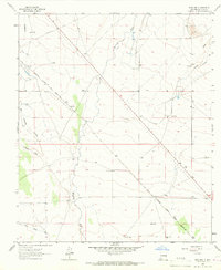
1964 Map of Spalding
USGS Topo · Published 1967About this map
The Butterfield Trail cuts diagonally across this high desert landscape, tracing the historic path of nineteenth-century stagecoaches through Luna County. This 1960s survey documents a region defined by its vital water sources and transportation corridors, where the Mimbres River and San Vicente Arroyo provide the primary relief in an arid environment. The settlement at Spalding sits along the Atchison Topeka and Santa Fe railroad line, which parallels the river valley. Numerous livestock improvements are scattered throughout the quadrangle, including the Gerrell Windmill, East Windmill, and several numbered stations like Windmill No 6. The transition from old trails to modern infrastructure is evident as U.S. Route 180 follows a similar path as the historic stage route, while the presence of a Landing Strip and Radio Tower marks the mid-century development of the area.
Find a feature on this map
27 named features on this map. Tap any name to fly to it.
Don’t see what you’re looking for? This feature index may not catch every label — zoom into the map to look around manually.
Map Details
Editions of this 1964 Spalding Map
This is the sole edition of this map. No revisions or reprints were ever made.
Other maps of this area

1899 · Deming
USGS Topo · 1:125,000

1909 · Silver City
USGS Topo · 1:125,000

1915 · Deming
USGS Topo · 1:125,000

1947 · Faywood Station
USGS Topo · 1:24,000

1949 · Faywood Station
USGS Topo · 1:24,000

1954 · Silver City
USGS Topo · 1:250,000

1955 · Las Cruces
USGS Topo · 1:250,000

1956 · Dwyer
USGS Topo · 1:62,500

1958 · Las Cruces
USGS Topo · 1:250,000

1958 · Silver City
USGS Topo · 1:250,000