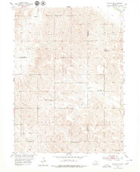
1954 Map of Spalding SE
USGS Topo · Published 1979About this map
Leo Valley and the surrounding Nebraska townships of Dublin, Logan, and Cedar are documented here as part of a mid-century effort by the Department of the Interior to develop the Missouri River Basin. The landscape is defined by the drainage systems of Cedar R and Timber Creek, with the North Branch and South Branch Timber Creek carving into the terrain. This area reflects a dense network of early rural education, evidenced by numerous local schoolhouses including Criss Sch, Leo Valley Sch, and Sleepy Hollow Sch. The presence of School No 80 (Abandoned) highlights the shifting demographics and consolidation of these prairie districts. Genealogists will find the Enfield Cemetery near Enfield Sch, situated along the boundary of Greeley Co and Boone Co.
Find a feature on this map
18 named features on this map. Tap any name to fly to it.
Don’t see what you’re looking for? This feature index may not catch every label — zoom into the map to look around manually.
Map Details
Editions of this 1954 Spalding SE Map
Other maps of this area

1899 · St. Paul
USGS Topo · 1:125,000

1954 · Cedar Rapids
USGS Topo · 1:24,000

1954 · Spalding
USGS Topo · 1:24,000

1954 · Spalding SW
USGS Topo · 1:24,000

1954 · Wolbach
USGS Topo · 1:24,000

1954 · Akron
USGS Topo · 1:24,000

1954 · Wolbach NE
USGS Topo · 1:24,000

1954 · Spalding NW
USGS Topo · 1:24,000

1954 · Belgrade NW
USGS Topo · 1:24,000

1954 · Spalding SE
USGS Topo · 1:24,000