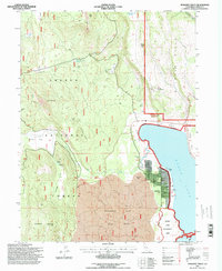
1995 Map of Spalding Tract
USGS Topo · Published 1998About this map
Eagle Lake defines the eastern edge of this landscape, where the Spalding Tract residential development sits adjacent to the shoreline and the Spaulding Airport. The terrain reflects a transition from the volcanic geology of the Lava Beds on Brockman Flat to the timbered reaches of the Lassen National Forest. Evidence of local utility and early habitation is scattered throughout the hills, from the Old Spalding Cabin near the lake to the remote Houseman Camp and its associated Houseman Camp Reservoir. The map tracks several water sources critical to this high-country environment, including Pine Creek, which is spanned by the Pine Bridge, and several isolated wells such as Gordon Well and Dow Wells. Conservation and recreation are significant themes, noted by the presence of the Osprey Game Management Area near the southern lakefront.
Find a feature on this map
35 named features on this map. Tap any name to fly to it.
Don’t see what you’re looking for? This feature index may not catch every label — zoom into the map to look around manually.
Map Details
Editions of this 1995 Spalding Tract Map
This is the sole edition of this map. No revisions or reprints were ever made.
Other maps of this area

1886 · Honey Lake
USGS Topo · 1:250,000

1891 · Honey Lake
USGS Topo · 1:250,000

1893 · Honey Lake
USGS Topo · 1:250,000

1954 · Grasshopper Valley
USGS Topo · 1:62,500

1954 · Fredonyer Peak
USGS Topo · 1:62,500

1955 · Westwood
USGS Topo · 1:250,000

1956 · Hayden Hill
USGS Topo · 1:62,500

1956 · Antelope Mtn
USGS Topo · 1:62,500

1958 · Westwood
USGS Topo · 1:250,000

1959 · Westwood
USGS Topo · 1:250,000