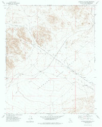
1973 Map of Spangler Hills East
USGS Topo · Published 1976About this map
The Spangler Hills dominate the western landscape of this mid-1970s survey, marking a transition into the vast desert basin of the Searles Valley. This map captures the area's significance as a military installation, with a substantial portion of the terrain designated as the China Lake Naval Weapons Center. The topographical detail reveals a land defined by ephemeral drainage systems like Randsburg Wash and Teagle Wash, which flow toward a central depression. The infrastructure of the era is represented by the Trona Road and various Jeep Trails, providing access to isolated desert points. Minor industrial and exploratory marks, such as a Borrow Pit, a Prospect, and a Dry Well, hint at the sporadic mineral interest and water challenges common to this arid San Bernardino County region.
Find a feature on this map
15 named features on this map. Tap any name to fly to it.
Don’t see what you’re looking for? This feature index may not catch every label — zoom into the map to look around manually.
Map Details
Editions of this 1973 Spangler Hills East Map
This is the sole edition of this map. No revisions or reprints were ever made.
Other maps of this area

1903 · Randsburg
USGS Topo · 1:62,500

1911 · Randsburg
USGS Topo · 1:62,500

1912 · Randsburg
USGS Topo · 1:62,500

1915 · Searles Lake
USGS Topo · 1:250,000

1947 · Trona
USGS Topo · 1:250,000

1948 · Trona
USGS Topo · 1:250,000

1949 · Searles Lake
USGS Topo · 1:62,500

1950 · Searles Lake
USGS Topo · 1:62,500

1953 · Ridgecrest
USGS Topo · 1:62,500

1953 · Trona
USGS Topo · 1:250,000