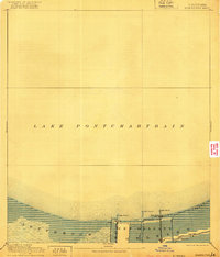
1891 Map of Spanish Fort
USGS Topo · Published 1921About this map
Lake Pontchartrain dominates the northern half of this coastal survey, defining the late 19th-century relationship between the city and the water. The southern shoreline is a landscape of established lakeside settlements and vital navigation works, including the New Basin Canal and the strategically placed Light House structures guarding the approach. The transition from Jefferson to New Orleans is marked by a network of waterways like St. Johns Bayou and Bayou Sauvage, which historically facilitated drainage and transport in this low-lying area. At the water's edge, Spanish Fort and Milneburg appear as prominent landing points, with the N. O. & N. E. railroad extending toward the marshy reaches of Gentilly. The 1890 survey data shows the early shoreline infrastructure before the major 20th-century expansions into the lake.
Find a feature on this map
13 named features on this map. Tap any name to fly to it.
Don’t see what you’re looking for? This feature index may not catch every label — zoom into the map to look around manually.
Map Details
Editions of this 1891 Spanish Fort Map
4 editions found
Other maps of this area

1891 · Hahnville
USGS Topo · 1:62,500

1891 · Spanish Fort
USGS Topo · 1:62,500

1891 · New Orleans
USGS Topo · 1:62,500

1892 · Chef Menteur
USGS Topo · 1:62,500

1892 · Bonnet Carre
USGS Topo · 1:62,500

1892 · St. Bernard
USGS Topo · 1:62,500

1932 · New Orleans NE
USGS Topo · 1:31,680

1932 · New Orleans NW
USGS Topo · 1:31,680

1932 · Hahnville NE
USGS Topo · 1:31,680

1935 · Slidell
USGS Topo · 1:62,500