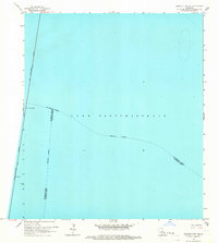
1965 Map of Spanish Fort NE
USGS Topo · Published 1966About this map
Lake Pontchartrain dominates this mid-1960s hydrographic survey, revealing the vast expanse of open water where three Louisiana parishes meet. The Lake Pontchartrain Causeway (Toll) cuts a straight path across the western edge of the sheet, providing a vital transportation link between the north and south shores. This edition reflects the mid-century infrastructure of the region, featuring the Small Craft Passage and a Turnaround along the bridge structure.
Find a feature on this map
7 named features on this map. Tap any name to fly to it.
Don’t see what you’re looking for? This feature index may not catch every label — zoom into the map to look around manually.
Map Details
Editions of this 1965 Spanish Fort NE Map
2 editions found
Other maps of this area

1891 · Spanish Fort
USGS Topo · 1:62,500

1892 · Chef Menteur
USGS Topo · 1:62,500

1935 · Slidell
USGS Topo · 1:62,500

1935 · Covington
USGS Topo · 1:62,500

1936 · South Point
USGS Topo · 1:31,680

1936 · Chef Menteur
USGS Topo · 1:62,500

1936 · Spanish Fort
USGS Topo · 1:62,500

1938 · Little Woods
USGS Topo · 1:31,680
1938 · Spanish Fort
USGS Topo · 1:31,680
1938 · Indian Beach
USGS Topo · 1:31,680