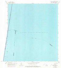
1965 Map of Spanish Fort NE
USGS Topo · Published 1973About this map
Lake Pontchartrain dominates this mid-1960s survey, illustrating the maritime expanse where the boundaries of several Louisiana parishes converge. The most prominent structural feature is the Lake Pontchartrain Causeway (Toll), which cuts a nearly straight north-south line across the open water. This engineering feat facilitated regional connectivity between the north and south shores during a period of significant growth. The map also delineates the Indefinite Boundary shared by St Tammany Parish, Jefferson Parish, and Orleans Parish, reflecting the complex jurisdictional geography of the lake. Mariners of the era would have noted the designated Small Craft Passage along the causeway, providing essential transit points for smaller vessels navigating these large coastal waters.
Find a feature on this map
7 named features on this map. Tap any name to fly to it.
Don’t see what you’re looking for? This feature index may not catch every label — zoom into the map to look around manually.
Map Details
Editions of this 1965 Spanish Fort NE Map
2 editions found
Other maps of this area

1891 · Spanish Fort
USGS Topo · 1:62,500

1892 · Chef Menteur
USGS Topo · 1:62,500

1935 · Slidell
USGS Topo · 1:62,500

1935 · Covington
USGS Topo · 1:62,500

1936 · South Point
USGS Topo · 1:31,680

1936 · Chef Menteur
USGS Topo · 1:62,500

1936 · Spanish Fort
USGS Topo · 1:62,500

1938 · Little Woods
USGS Topo · 1:31,680
1938 · Spanish Fort
USGS Topo · 1:31,680
1938 · Indian Beach
USGS Topo · 1:31,680