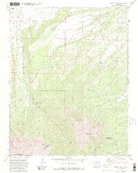
1971 Map of Spanish Peaks
USGS Topo · Published 1982About this map
East Spanish Peak and West Spanish Peak anchor this high-altitude survey of the Huerfano and Las Animas county border. Part of the Isabel National Forest, the landscape is defined by steep drainages like Schultz Canyon and Long Canyon, alongside prominent geological features such as the Big Wall and Lovers Leap. These formations provided a dramatic backdrop for mid-century recreational and educational outposts including Wahatoya Camp and the Santa Fe Trail Council Camp.
Find a feature on this map
29 named features on this map. Tap any name to fly to it.
Don’t see what you’re looking for? This feature index may not catch every label — zoom into the map to look around manually.
Map Details
Editions of this 1971 Spanish Peaks Map
4 editions found
Other maps of this area

1889 · Huerfano Park
USGS Topo · 1:125,000

1891 · Walsenburg
USGS Topo · 1:125,000

1891 · Spanish Peaks
USGS Topo · 1:125,000

1892 · Huerfano Park
USGS Topo · 1:125,000

1893 · Spanish Peaks
USGS Topo · 1:125,000

1894 · Walsenburg
USGS Topo · 1:125,000

1895 · Spanish Peaks
USGS Topo · 1:125,000

1897 · Walsenburg
USGS Topo · 1:125,000

1897 · Spanish Peaks
USGS Topo · 1:125,000

1900 · Spanish Peaks
USGS Topo · 1:125,000