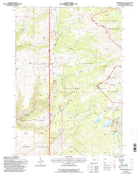
1993 Map of Spanish Point
USGS Topo · Published 1997About this map
Medicine Lodge Big Game Winter Range dominates the southwest corner of this landscape, where the high-altitude topography of the Bighorn National Forest meets specialized wildlife management areas. The drainage network is complex, defined by the westward flow of Medicine Lodge Creek and its tributary Dry Medicine Lodge Creek, carving deep into the Canyon terrain. In the east, the transition into the Cloud Peak Wilderness is marked by a concentration of glacial lakes, including Upper Paint Rock Lake and Lower Medicine Lodge Lake. Human presence is largely seasonal and administrative, centered around Paint Rock Lodge and the Paint Rock Lakes Guard Station. Transportation through this steep environment relies on a network of historic paths such as the Edelman Trail and Kinky White Trail, which provide access to the prominent heights of Iron Mountain and the broad plateau of Spanish Point.
Find a feature on this map
50 named features on this map. Tap any name to fly to it.
Don’t see what you’re looking for? This feature index may not catch every label — zoom into the map to look around manually.
Map Details
Editions of this 1993 Spanish Point Map
This is the sole edition of this map. No revisions or reprints were ever made.
Other maps of this area

1895 · Dayton
USGS Topo · 1:125,000

1898 · Bald Mountain
USGS Topo · 1:125,000

1899 · Cloud peak
USGS Topo · 1:125,000

1901 · Cloud Peak
USGS Topo · 1:125,000

1901 · Dayton
USGS Topo · 1:125,000

1901 · Bald Mountain
USGS Topo · 1:125,000

1955 · Sheridan
USGS Topo · 1:250,000

1958 · Sheridan
USGS Topo · 1:250,000

1960 · Shell Falls
USGS Topo · 1:24,000

1960 · Shell Lake
USGS Topo · 1:24,000