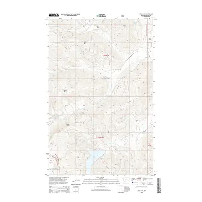
2014 Map of Spar Lake
USGS Topo · Published 2014About this map
Spar Lake lies at the heart of this high-elevation landscape in the northwest corner of Montana, situated within the vast expanse of the Kootenai National Forest. The map documents a rugged section of the Cabinet Mountains, characterized by prominent peaks like Stanley Peak and Stanley Mtn, alongside the distinct volcanic profile of Lime Butte. The drainage patterns are defined by a complex network of creeks including Keeler Cr and Stanley Cr, while smaller alpine waters such as Spruce Lake and Grouse Lake dot the higher elevations. The presence of Asarco Rd hints at the industrial history of the region, where mineral exploration and timber management have long shaped the land. This survey provides a meticulous record of the boundary between the Kootenai and Kanisku National Forest, as well as the intricate system of forest development roads like the N Fork Keeler Rd that provide access to this isolated mountain terrain.
Find a feature on this map
43 named features on this map. Tap any name to fly to it.
Don’t see what you’re looking for? This feature index may not catch every label — zoom into the map to look around manually.
Map Details
Editions of this 2014 Spar Lake Map
This is the sole edition of this map. No revisions or reprints were ever made.
Other maps of this area

1911 · Priest Lake
USGS Topo · 1:250,000

1913 · Priest Lake
USGS Topo · 1:250,000

1920 · Libby
USGS Topo · 1:125,000

1930 · Libby
USGS Topo · 1:125,000

1932 · Libby
USGS Topo · 1:125,000

1951 · Clark Fork
USGS Topo · 1:62,500

1951 · Mt Pend Oreille
USGS Topo · 1:62,500

1957 · Kalispell
USGS Topo · 1:250,000

1958 · Sandpoint
USGS Topo · 1:250,000

1960 · Kalispell
USGS Topo · 1:250,000