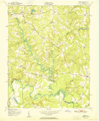
1951 Map of Sparta
USGS Topo · Published 1951About this map
Sparta and the surrounding rural landscape of the Virginia Coastal Plain appear here during the mid-century. The area is defined by the winding course of the Mattaponi River and its numerous tributaries, including Maracossic Creek and Beverly Run. This 1951 record captures a series of small, crossroad settlements such as Beale, Alps, and Central Point, which served the local agricultural community. Local infrastructure and community life are well-documented through the presence of mills and religious centers, including Broaddus Mill Pond, Byrds Mill Pond, and several local houses of worship like Salem Ch and Shiloh Ch. A clear educational landmark is preserved at the Jerusalem Sch near Jerusalem. The map also illustrates the convergence of three counties—Caroline, King and Queen, and King William—showing how jurisdictional boundaries were woven into the natural drainage patterns of the river valley.
Find a feature on this map
35 named features on this map. Tap any name to fly to it.
Don’t see what you’re looking for? This feature index may not catch every label — zoom into the map to look around manually.
Map Details
Editions of this 1951 Sparta Map
2 editions found
Other maps of this area

1889 · Fredericksburg
USGS Topo · 1:125,000

1892 · Fredericksburg
USGS Topo · 1:125,000

1894 · Fredericksburg
USGS Topo · 1:125,000

1918 · Doswell
USGS Topo · 1:62,500

1918 · Aylett
USGS Topo · 1:62,500

1933 · Aylett
USGS Topo · 1:62,500

1942 · Bowling Green
USGS Topo · 1:31,680

1942 · Upper Zion
USGS Topo · 1:31,680

1942 · Occupacia
USGS Topo · 1:31,680

1943 · Richmond
USGS Topo · 1:250,000