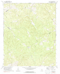
1972 Map of Sparta NW
USGS Topo · Published 1991About this map
Springfield and Powelton anchor this rural landscape in the early 1970s, situated where the boundaries of Greene, Taliaferro, and Hancock counties converge. The terrain is defined by a dense network of waterways feeding into the Ogeechee River in the northeast corner, including Lacy Creek, Johnson Creek, and Powell Creek. Cultural history is preserved through scattered rural landmarks like Battery Ch and Antioch Ch, alongside smaller family and community burial grounds such as Dixon Cem and Antioch Cem. The mapping shows a predominantly agricultural and wooded character, with a notable Pipeline cutting through the center of the sheet and several unnamed graves and cemeteries marking the locations of earlier homesteads. The convergence of Battle Branch and Beaverdam Branch underscores the heavy influence of the watershed on the historical settlement patterns of this Middle Georgia region.
Find a feature on this map
22 named features on this map. Tap any name to fly to it.
Don’t see what you’re looking for? This feature index may not catch every label — zoom into the map to look around manually.
Map Details
Editions of this 1972 Sparta NW Map
2 editions found
Other maps of this area

1906 · Crawfordville
USGS Topo · 1:125,000

1953 · Athens
USGS Topo · 1:250,000

1958 · Athens
USGS Topo · 1:250,000

1959 · Athens
USGS Topo · 1:250,000

1963 · Athens
USGS Topo · 1:250,000

1965 · Union Point
USGS Topo · 1:24,000

1966 · Crawfordville
USGS Topo · 1:24,000

1972 · Shoulderbone
USGS Topo · 1:24,000

1972 · Sharon
USGS Topo · 1:24,000

1972 · Sparta NW
USGS Topo · 1:24,000