
1972 Map of Sharon
USGS Topo · Published 1974About this map
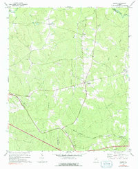
Sharon serves as the central hub of this Georgia landscape, situated at a road junction in the heart of Taliaferro County during the early 1970s. The map illustrates a rural environment defined by small settlements and a dense network of watercourses, including the Little River along the northern border and Williams Creek to the south. Local landmarks such as the Lookout Tower near Level Hill Ch provide orientation points for researchers tracking the physical geography of the era. Settlement patterns are concentrated around intersections and water sources, with Sandy Cross and Raytown appearing as distinct communities. Genealogy-rich details include numerous country churches like Mt Olive Ch and Jennings Ch, alongside several unnamed cemeteries that mark family and community history across the rolling terrain between Kindrick Creek and Reedy Creek.
Find a feature on this map
23 named features on this map. Tap any name to fly to it.
Don’t see what you’re looking for? This feature index may not catch every label — zoom into the map to look around manually.
Map Details
Editions of this 1972 Sharon Map
2 editions found
Other maps of this area

1906 · Crawfordville
USGS Topo · 1:125,000

1953 · Athens
USGS Topo · 1:250,000

1958 · Athens
USGS Topo · 1:250,000

1959 · Athens
USGS Topo · 1:250,000

1963 · Athens
USGS Topo · 1:250,000

1966 · Philomath
USGS Topo · 1:24,000

1966 · Crawfordville
USGS Topo · 1:24,000

1972 · Sparta NW
USGS Topo · 1:24,000
1972 · Cadley
USGS Topo · 1:24,000
1972 · Washington East
USGS Topo · 1:24,000