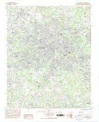
1983 Map of Spartanburg
USGS Topo · Published 1983About this map
Spartanburg is documented here as a thriving educational and regional hub during the early 1980s, characterized by a dense concentration of academic institutions including Wofford College, Converse College, and the Univ of S C Spartanburg. The landscape is a mix of established residential neighborhoods like Converse Heights and Saxon, industrial rail corridors including the Seaboard and Southern lines, and expanding suburban reaches such as West View and East Spartanburg.
Find a feature on this map
90 named features on this map. Tap any name to fly to it.
Don’t see what you’re looking for? This feature index may not catch every label — zoom into the map to look around manually.
Map Details
Editions of this 1983 Spartanburg Map
2 editions found
Other maps of this area

1907 · Saluda
USGS Topo · 1:125,000

1935 · Greer
USGS Topo · 1:48,000

1938 · Greer
USGS Topo · 1:62,500

1941 · Spartanburg
USGS Topo · 1:250,000

1947 · Spartanburg
USGS Topo · 1:62,500

1949 · Spartanburg
USGS Topo · 1:24,000

1949 · Spartanburg
USGS Topo · 1:62,500

1953 · Spartanburg
USGS Topo · 1:250,000

1953 · Charlotte
USGS Topo · 1:250,000

1954 · Charlotte
USGS Topo · 1:250,000