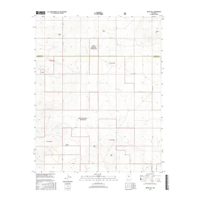
2017 Map of Spear Hills
USGS Topo · Published 2017About this map
Kiowa National Grassland dominates this high-plains landscape, where the boundary between Colfax Co and Harding Co cuts across the northern cattle country. The terrain is defined by a network of drainage features like Hubsch Draw and Alex Draw in the north, while the southern reaches are marked by the Spear Hills and Spear Draw. This 2017 survey reflects the contemporary ranching infrastructure of Northeastern New Mexico, tracing a grid of rural roads such as Co Rd C-38 and Shaw Ranch Rd. Local elevation shifts are visible at Chateau Hill and along the seasonal watercourses of Carrizo Cr and Arroyo Ojo Verde, which feed into the larger Canadian River watershed system beyond these borders.
Find a feature on this map
29 named features on this map. Tap any name to fly to it.
Don’t see what you’re looking for? This feature index may not catch every label — zoom into the map to look around manually.
Map Details
Editions of this 2017 Spear Hills Map
This is the sole edition of this map. No revisions or reprints were ever made.
Other maps of this area

1954 · Raton
USGS Topo · 1:250,000

1958 · Raton
USGS Topo · 1:250,000

1965 · Abbott
USGS Topo · 1:24,000

1971 · Abbott Lake
USGS Topo · 1:24,000

1972 · Mills West
USGS Topo · 1:24,000
1974 · Kansas Valley
USGS Topo · 1:24,000

1974 · Farley
USGS Topo · 1:24,000
1974 · Mills East
USGS Topo · 1:24,000

1974 · Spear Hills
USGS Topo · 1:24,000
1974 · Divine Lake
USGS Topo · 1:24,000