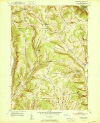
1951 Map of Speedsville
USGS Topo · Published 1951About this map
The boundary between Tompkins Co and Tioga Co bisects this 1951 survey, capturing a landscape of steep hills and narrow valleys during the mid-century transition. The settlement of Speedsville sits at the eastern edge where Boyer Creek meets the West Branch Owego Creek, while smaller communities like Caroline Center and Upper Fairfield are connected by a dense network of early roads. The Catskill Turnpike crosses the northern heights, a reminder of the region's early importance as a transit corridor.
Find a feature on this map
60 named features on this map. Tap any name to fly to it.
Don’t see what you’re looking for? This feature index may not catch every label — zoom into the map to look around manually.
Map Details
Editions of this 1951 Speedsville Map
This is the sole edition of this map. No revisions or reprints were ever made.
Other maps of this area

1900 · Dryden
USGS Topo · 1:62,500

1901 · Apalachin
USGS Topo · 1:62,500

1903 · Owego
USGS Topo · 1:62,500

1903 · Harford
USGS Topo · 1:62,500

1904 · Apalachin
USGS Topo · 1:62,500

1906 · Catatonk
USGS Topo · 1:125,000

1949 · Ithaca East
USGS Topo · 1:24,000

1949 · Willseyville
USGS Topo · 1:24,000
1949 · Dryden
USGS Topo · 1:24,000

1949 · Speedsville
USGS Topo · 1:24,000