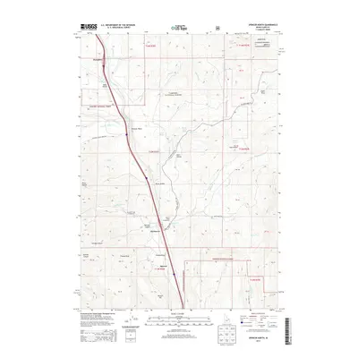
2013 Map of Spencer North
USGS Topo · Published 2013About this map
Beaver Creek carves a central path through this high-altitude landscape on the southern slopes of the Centennial Mountains. The small community of Spencer and the nearby settlement at Old Beaver anchor the southern portion of the sheet, where the drainage of Thomas Draw meets the valley floor. To the north, the corridor follows the water toward Pleasant Valley and the small enclave of Humphrey. This terrain is defined by its seasonal importance and transition from the Snake River Plain toward the continental divide, evidenced by sites like Stoddard Creek Campground and Beaver Creek Campground. Numerous family-named and geographical landmarks, such as Van Noy Canyon, Huntley Canyon, and Beacon Hill, suggest a history of ranching and early mountain transit. The landscape is heavily marked by the Targhee National Forest boundary and complex public land survey system tracts, reflecting the managed character of this Idaho-Montana border region.
Find a feature on this map
63 named features on this map. Tap any name to fly to it.
Don’t see what you’re looking for? This feature index may not catch every label — zoom into the map to look around manually.
Map Details
Editions of this 2013 Spencer North Map
This is the sole edition of this map. No revisions or reprints were ever made.
Other maps of this area

1955 · Dubois
USGS Topo · 1:250,000

1957 · Paul Reservoir
USGS Topo · 1:62,500

1958 · Dubois
USGS Topo · 1:250,000

1968 · Corral Creek
USGS Topo · 1:24,000

1968 · Big Table Mountain
USGS Topo · 1:24,000

1968 · Monida
USGS Topo · 1:24,000

1972 · Spencer South
USGS Topo · 1:24,000

1972 · Spencer North
USGS Topo · 1:24,000
1972 · Lookout Point
USGS Topo · 1:24,000
1972 · Gardner Lake
USGS Topo · 1:24,000