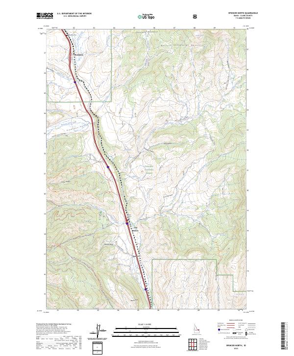
2023 Map of Spencer North
USGS Topo · Published 2023About this map
Beaver Creek carves a critical corridor through the Centennial Mountains in this high-altitude section of Clark County. The settlement of Spencer and the historical site of Old Beaver anchor the central valley, where the topography shifts from the steep walls of Van Noy Canyon to the broad expanse of Pleasant Valley. This area serves as a primary passage between the Snake River Plain and the Monida Pass, evidenced by the concentration of cemeteries and named settlements along the north-south drainage. Within the Targhee National Forest, a network of trails such as the Stoddard Creek Trl and Huntley Canyon Trl provides access to the high ridges of the Western Centennial Mountains. Smaller features like Humphrey Cem and Beaver Canyon Cem offer vital clues for genealogists researching the early families who settled this challenging terrain.
Find a feature on this map
78 named features on this map. Tap any name to fly to it.
Don’t see what you’re looking for? This feature index may not catch every label — zoom into the map to look around manually.
Map Details
Editions of this 2023 Spencer North Map
This is the sole edition of this map. No revisions or reprints were ever made.
Other maps of this area

1955 · Dubois
USGS Topo · 1:250,000

1957 · Paul Reservoir
USGS Topo · 1:62,500

1958 · Dubois
USGS Topo · 1:250,000

1968 · Corral Creek
USGS Topo · 1:24,000

1968 · Big Table Mountain
USGS Topo · 1:24,000

1968 · Monida
USGS Topo · 1:24,000

1972 · Spencer South
USGS Topo · 1:24,000

1972 · Spencer North
USGS Topo · 1:24,000
1972 · Lookout Point
USGS Topo · 1:24,000
1972 · Gardner Lake
USGS Topo · 1:24,000