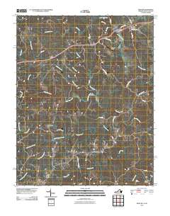
2010 Map of Spencer
USGS Topo · Published 2010About this map
The North Mayo River and South Mayo River define the drainage of this borderland region between Virginia and North Carolina. Small rural communities like Amostown and Sandy Ridge anchor the southern portion of the sheet, while the northern extent includes Spencer and the aviation facilities at Covington Airport. The landscape is a network of winding roads and numerous waterways, including Buffalo Creek, Crooked Creek, and Spoon Creek. Genealogists may find value in the specific locations of the Harris Cemetery and Gibson Cemetery near the southeastern corner, as well as the landmark at Sheppards Mill. The inclusion of Old Well Crossing and various family-named roads like Pratt Rd and Moores Mill Rd suggests a landscape shaped by long-standing local property lines and traditional river crossings.
Find a feature on this map
40 named features on this map. Tap any name to fly to it.
Don’t see what you’re looking for? This feature index may not catch every label — zoom into the map to look around manually.
Map Details
Editions of this 2010 Spencer Map
This is the sole edition of this map. No revisions or reprints were ever made.
Other maps of this area

1924 · Martinsville
USGS Topo · 1:48,000

1926 · Martinsville
USGS Topo · 1:62,500

1926 · Critz
USGS Topo · 1:48,000

1927 · Martinsville
USGS Topo · 1:62,500

1928 · Critz
USGS Topo · 1:62,500

1944 · Martinsville
USGS Topo · 1:62,500

1953 · Winston-Salem
USGS Topo · 1:250,000

1953 · Greensboro
USGS Topo · 1:250,000

1954 · Greensboro
USGS Topo · 1:250,000

1955 · Winston-Salem
USGS Topo · 1:250,000