
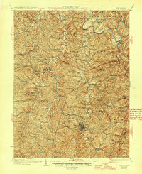
1928 Map of Spencer
USGS Topo · Published 1928About this map
Spencer serves as the focal point for this 1920s interior West Virginia landscape, situated at the confluence of several branches of Spring Creek. The town's industrial and educational character is marked by College Hill and its proximity to the Baltimore and Ohio railroad line. The rail network facilitates trade through local stops like Billings Sta and Kyger, connecting the remote hills and hollows of Reedy and Smithfield to the regional economy.
Find a feature on this map
151 named features on this map. Tap any name to fly to it.
Don’t see what you’re looking for? This feature index may not catch every label — zoom into the map to look around manually.
Map Details
Editions of this 1928 Spencer Map
2 editions found
Other maps of this area

1906 · Elizabeth
USGS Topo · 1:62,500

1906 · Belleville
USGS Topo · 1:62,500

1906 · Kenna
USGS Topo · 1:62,500

1906 · Otter
USGS Topo · 1:62,500

1906 · Walton
USGS Topo · 1:62,500

1907 · Kenna
USGS Topo · 1:62,500

1907 · Otter
USGS Topo · 1:62,500

1907 · Harrisville
USGS Topo · 1:62,500

1907 · Arnoldsburg
USGS Topo · 1:62,500

1907 · Spencer
USGS Topo · 1:62,500