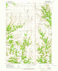
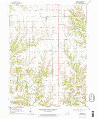
1964 Map of Sperry
USGS Topo · Published 1965About this map
Sperry and Dodgeville anchor this mid-1960s portrait of Des Moines County, where the transition from industrial utility to rural farmstead is clearly defined. The northern section is marked by heavy infrastructure, including a Gypsum Plant and Water Tank near the Chicago Rock Island and Pacific railroad line. This transport corridor served as the primary artery for the small settlements of Yellow Springs and Benton townships.
Find a feature on this map
23 named features on this map. Tap any name to fly to it.
Don’t see what you’re looking for? This feature index may not catch every label — zoom into the map to look around manually.
Map Details
Editions of this 1964 Sperry Map
2 editions found
Other maps of this area

1934 · Burlington
USGS Topo · 1:48,000

1940 · Burlington
USGS Topo · 1:62,500

1946 · Wapello
USGS Topo · 1:62,500

1949 · Wapello
USGS Topo · 1:62,500

1958 · Burlington
USGS Topo · 1:250,000

1958 · Davenport
USGS Topo · 1:250,000

1961 · Burlington
USGS Topo · 1:250,000

1961 · Davenport
USGS Topo · 1:250,000

1962 · Davenport
USGS Topo · 1:250,000

1963 · Burlington
USGS Topo · 1:250,000