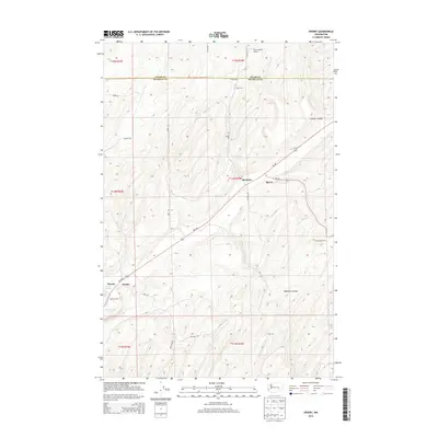
2014 Map of Sperry
USGS Topo · Published 2014About this map
Sperry and McAdam anchor this high-plateau landscape along the Adams and Franklin County line during the early twenty-first century. The area is defined by the sharp transition between agricultural plateaus and the dramatic incisions of Skookum Canyon and Collier Coulee. Named family operations like Ross Farm, Nanamaker Farm, and the Harder Ranch reflect a persistent ranching and dry-land farming legacy. Transport routes Wa-260 and Wa-261 converge near the rail siding at Sperry, while local aviation is served by the Fisher Ranch Airport. Water remains a vital but sparse resource in this environment, represented by Harder Spring and the basin of Washtucna Lake at the southwestern edge. The map also identifies smaller loading points or historical sites such as Harder and Wacota, illustrating the sparse but deliberate distribution of human activity across this deeply eroded terrain.
Find a feature on this map
25 named features on this map. Tap any name to fly to it.
Don’t see what you’re looking for? This feature index may not catch every label — zoom into the map to look around manually.
Map Details
Editions of this 2014 Sperry Map
This is the sole edition of this map. No revisions or reprints were ever made.
Other maps of this area

1916 · Connell
USGS Topo · 1:125,000

1918 · Connell
USGS Topo · 1:125,000

1923 · Washtucna
USGS Topo · 1:62,500

1925 · Washtucna
USGS Topo · 1:62,500

1948 · Ayer
USGS Topo · 1:62,500

1950 · Haas
USGS Topo · 1:62,500

1953 · Walla Walla
USGS Topo · 1:250,000

1958 · Walla Walla
USGS Topo · 1:250,000
1970 · Lower Monumental Dam
USGS Topo · 1:24,000

1970 · Lind SE
USGS Topo · 1:24,000