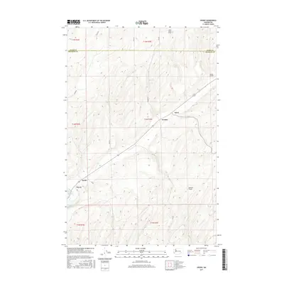
2017 Map of Sperry
USGS Topo · Published 2017About this map
Sperry and McAdam sit along a historic rail corridor in this 2017 survey of the borderlands between Adams and Franklin counties. The landscape is defined by the dramatic geomorphology of the Channeled Scablands, evidenced by features like Collier Coulee and Skookum Canyon. Settlement in this arid stretch of Eastern Washington is closely tied to water and transport, with small clusters like Harder and Wacota appearing near the southwestern corner of the sheet. Modern utility and ranching infrastructure are represented by the Fisher Ranch Airport and a network of rural routes including Gill Rd and Perry Rd. The presence of Washtucna Lake and Harder Spring highlights the critical, sparse water sources that have historically dictated the placement of ranches and rail stops in this high-desert environment.
Find a feature on this map
24 named features on this map. Tap any name to fly to it.
Don’t see what you’re looking for? This feature index may not catch every label — zoom into the map to look around manually.
Map Details
Editions of this 2017 Sperry Map
This is the sole edition of this map. No revisions or reprints were ever made.
Other maps of this area

1916 · Connell
USGS Topo · 1:125,000

1918 · Connell
USGS Topo · 1:125,000

1923 · Washtucna
USGS Topo · 1:62,500

1925 · Washtucna
USGS Topo · 1:62,500

1948 · Ayer
USGS Topo · 1:62,500

1950 · Haas
USGS Topo · 1:62,500

1953 · Walla Walla
USGS Topo · 1:250,000

1958 · Walla Walla
USGS Topo · 1:250,000
1970 · Lower Monumental Dam
USGS Topo · 1:24,000

1970 · Lind SE
USGS Topo · 1:24,000