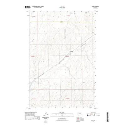
2020 Map of Sperry
USGS Topo · Published 2020About this map
Sperry and Harder are primary points of reference on this landscape of eastern Washington, situated along the diagonal path of the Columbia Plateau State Park Trail. This trail follows a historic transportation corridor that connects small locales like McAdam and Wacota, tracing the relief of the plateau. The terrain is defined by deep geological cuts such as Skookum Canyon and Collier Coulee, which disrupt the agricultural grid pattern established by local roads like S Bauer Rd and Gill Rd. Near the settlement of Harder, Harder Spring provides a rare mapped water source in this dry environment. The presence of the Fisher Ranch Airport in the northern portion of the quadrangle indicates the ongoing importance of private aviation for managing large landholdings across the Adams and Franklin county line.
Find a feature on this map
19 named features on this map. Tap any name to fly to it.
Don’t see what you’re looking for? This feature index may not catch every label — zoom into the map to look around manually.
Map Details
Editions of this 2020 Sperry Map
This is the sole edition of this map. No revisions or reprints were ever made.
Other maps of this area

1916 · Connell
USGS Topo · 1:125,000

1918 · Connell
USGS Topo · 1:125,000

1923 · Washtucna
USGS Topo · 1:62,500

1925 · Washtucna
USGS Topo · 1:62,500

1948 · Ayer
USGS Topo · 1:62,500

1950 · Haas
USGS Topo · 1:62,500

1953 · Walla Walla
USGS Topo · 1:250,000

1958 · Walla Walla
USGS Topo · 1:250,000
1970 · Lower Monumental Dam
USGS Topo · 1:24,000

1970 · Lind SE
USGS Topo · 1:24,000