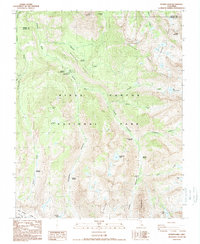
1988 Map of Sphinx Lakes
USGS Topo · Published 1988About this map
Kings Canyon National Park and Sequoia Nat Park converge in this high-altitude wilderness, defined by the meeting of Deadman Canyon and Cloud Canyon. The terrain is marked by glacial activity and seasonal meadows such as Scaffold Meadows and Big Wet Meadow. Human presence in this remote landscape is noted by back-country shelters including the Roaring River Ranger Station, Barton-Lackey Cabin, and Shortys Cabin located near the Roaring River. The intricate hydrology of the High Sierra is visible through the Sphinx Lakes chain and isolated waters like Josephine Lake and Colby Lake. The Kings-Kaweah Divide in the south provides a natural barrier between these iconic park lands, while landmarks like Whaleback and Table Mountain dominate the local relief.
Find a feature on this map
41 named features on this map. Tap any name to fly to it.
Don’t see what you’re looking for? This feature index may not catch every label — zoom into the map to look around manually.
Map Details
Editions of this 1988 Sphinx Lakes Map
This is the sole edition of this map. No revisions or reprints were ever made.
Other maps of this area

1903 · Tehipite
USGS Topo · 1:125,000

1905 · Tehipite
USGS Topo · 1:125,000

1907 · Mt. Whitney
USGS Topo · 1:125,000

1919 · Mt. Whitney
USGS Topo · 1:125,000

1937 · Mt. Whitney
USGS Topo · 1:125,000

1948 · Fresno
USGS Topo · 1:250,000

1953 · Mt. Pinchot
USGS Topo · 1:62,500

1953 · Marion Peak
USGS Topo · 1:62,500

1955 · Fresno
USGS Topo · 1:250,000

1956 · Fresno
USGS Topo · 1:250,000