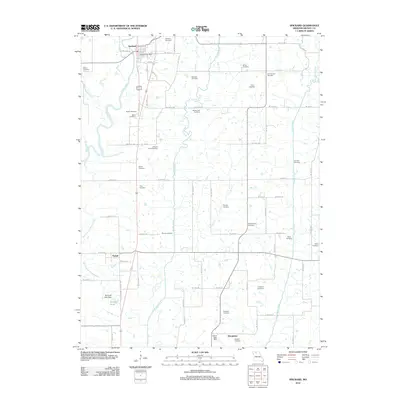
2012 Map of Spickard
USGS Topo · Published 2012About this map
The Weldon River and its meandering tributary system define the landscape of northern Grundy County in this modern survey. The town of Spickard serves as the primary hub, where the Spickard Post Office and Spickard Cemetery sit amidst a grid of rural routes. To the south, the smaller settlement of Tindall is located near the Old Channel Weldon River, indicating a shift in the river's historical course. The area is exceptionally dense with family-named burial grounds, providing a significant resource for genealogical research.
Find a feature on this map
73 named features on this map. Tap any name to fly to it.
Don’t see what you’re looking for? This feature index may not catch every label — zoom into the map to look around manually.
Map Details
Editions of this 2012 Spickard Map
This is the sole edition of this map. No revisions or reprints were ever made.
Other maps of this area

1946 · Princeton
USGS Topo · 1:62,500

1946 · Galt
USGS Topo · 1:62,500

1948 · Princeton
USGS Topo · 1:62,500

1948 · Trenton
USGS Topo · 1:62,500

1949 · Galt
USGS Topo · 1:62,500

1954 · Centerville
USGS Topo · 1:250,000

1957 · Centerville
USGS Topo · 1:250,000

1958 · Centerville
USGS Topo · 1:250,000

1964 · Half Rock
USGS Topo · 1:24,000
1981 · Trenton
USGS Topo · 1:100,000