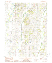
1984 Map of Spickard
USGS Topo · Published 1985About this map
Spickard anchor this rural Grundy County landscape, situated along the upper reaches of the Weldon River. This 1984 provisional survey illustrates the agricultural character of north-central Missouri during the late twentieth century, showing a network of rural routes and farmstead placements. The Chicago Rock Island and Pacific railroad corridor cuts through the western portion of the map, providing a historical transit link that mirrors the winding path of the river. To the south, the smaller settlement of Tindall sits near the banks of Muddy Creek. The terrain is defined by the drainage patterns of Honey Creek and the Old Channel, which reveal how the hydrology shaped local land use and township boundaries between Franklin and Lincoln. This map captures the region's established rural infrastructure just as modern mapping transitions were beginning.
Find a feature on this map
13 named features on this map. Tap any name to fly to it.
Don’t see what you’re looking for? This feature index may not catch every label — zoom into the map to look around manually.
Map Details
Editions of this 1984 Spickard Map
This is the sole edition of this map. No revisions or reprints were ever made.
Other maps of this area

1946 · Princeton
USGS Topo · 1:62,500

1946 · Galt
USGS Topo · 1:62,500

1948 · Princeton
USGS Topo · 1:62,500

1948 · Trenton
USGS Topo · 1:62,500

1949 · Galt
USGS Topo · 1:62,500

1954 · Centerville
USGS Topo · 1:250,000

1957 · Centerville
USGS Topo · 1:250,000

1958 · Centerville
USGS Topo · 1:250,000

1964 · Half Rock
USGS Topo · 1:24,000
1981 · Trenton
USGS Topo · 1:100,000