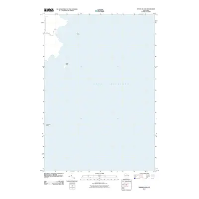
2010 Map of Spider Island
USGS Topo · Published 2010About this map
Spider Island and the surrounding waters of Lake Michigan define this coastal survey of the Door County peninsula's eastern edge. The map highlights the maritime hazards of the shoreline, specifically identifying Outer Shoal and the dangerously shallow Four Foot Shoal. Inland access is limited to the northern corridor where Newport Park Rd enters the landscape. This 2010 edition documents a largely undeveloped maritime environment, emphasizing the navigational features and natural topography of the island and its adjacent shoals rather than dense settlement. The focus on bathymetric hazards and isolated coastal features provides essential data for understanding the historical shipwrecks and navigational challenges common to this stretch of the Great Lakes.
Find a feature on this map
5 named features on this map. Tap any name to fly to it.
Don’t see what you’re looking for? This feature index may not catch every label — zoom into the map to look around manually.
Map Details
Editions of this 2010 Spider Island Map
This is the sole edition of this map. No revisions or reprints were ever made.
Other maps of this area

1954 · Escanaba
USGS Topo · 1:250,000

1957 · Escanaba
USGS Topo · 1:250,000

1958 · Escanaba
USGS Topo · 1:250,000

1960 · Washington Island
USGS Topo · 1:62,500

1960 · Sister Bay
USGS Topo · 1:62,500

1960 · Ellison Bay
USGS Topo · 1:62,500

1981 · Marinette
USGS Topo · 1:100,000

1982 · Washington Island SE
USGS Topo · 1:24,000
1982 · Ellison Bay
USGS Topo · 1:24,000
1982 · Baileys Harbor East
USGS Topo · 1:24,000