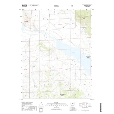
2019 Map of Spinney Mountain
USGS Topo · Published 2019About this map
Elevenmile Canyon Reservoir dominates the eastern landscape of this Park County region, where the South Platte River feeds into the expansive high-altitude basin. The terrain is defined by prominent peaks including Spinney Mtn and Stoll Mtn, while the Puma Hills rise within the protected boundaries of the Pike National Forest. A complex network of drainage systems, such as Chase Gulch, Boyer Gulch, and Pruden Cr, illustrates the hydrological patterns that sustain the local ecology. The map documents a modern infrastructure of rural and forest service routes, including Co Rd 59 and the Spinney Mountain Access Rd, which provide access to these remote reaches of the Rocky Mountains. The area remains largely undeveloped, characterized by the intersection of public forest lands and significant water resources.
Find a feature on this map
45 named features on this map. Tap any name to fly to it.
Don’t see what you’re looking for? This feature index may not catch every label — zoom into the map to look around manually.
Map Details
Editions of this 2019 Spinney Mountain Map
This is the sole edition of this map. No revisions or reprints were ever made.
Other maps of this area

1893 · Platte Canyon
USGS Topo · 1:125,000

1894 · Pikes Peak
USGS Topo · 1:125,000

1901 · Pikes Peak
USGS Topo · 1:125,000

1953 · Denver
USGS Topo · 1:250,000

1954 · Pueblo
USGS Topo · 1:250,000

1956 · Tarryall
USGS Topo · 1:24,000

1956 · Sulphur Mountain
USGS Topo · 1:24,000

1956 · Elevenmile Canyon
USGS Topo · 1:24,000

1956 · Guffey NW
USGS Topo · 1:24,000

1956 · Glentivar
USGS Topo · 1:24,000