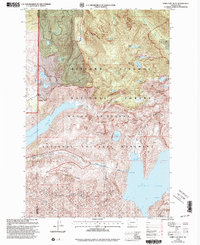
1998 Map of Spirit Lake West
USGS Topo · Published 2003About this map
Mount St Helens National Volcanic Monument dominates this landscape, reflecting the dramatic geological shifts of the late 20th century. The topography is defined by the massive Mud Flow following the North Fork Toutle River and the creation of Coldwater Lake north of Johnston Ridge. Scientific and public observation points like the Johnston Ridge Observatory and Loowit Viewpoint are established along the high ground, overlooking the blast zone. Significant engineering efforts to manage the altered watershed are visible, including the Spirit Lake Outlet Tunnel and its associated Tunnel Intake. To the north, the terrain transitions into the Gifford Pinchot National Forest, where a dense network of high-elevation lakes such as Deep Lake, Lonesome Lake, and Venus Lake remain tucked between peaks like Mount Venus and Minnie Peak.
Find a feature on this map
48 named features on this map. Tap any name to fly to it.
Don’t see what you’re looking for? This feature index may not catch every label — zoom into the map to look around manually.
Map Details
Editions of this 1998 Spirit Lake West Map
This is the sole edition of this map. No revisions or reprints were ever made.
Other maps of this area

1919 · Mount St Helens
USGS Topo · 1:125,000

1953 · Hoquiam
USGS Topo · 1:250,000

1953 · Cougar
USGS Topo · 1:62,500

1953 · Elk Rock
USGS Topo · 1:62,500

1957 · Hoquiam
USGS Topo · 1:250,000

1957 · Spirit Lake
USGS Topo · 1:62,500

1958 · Mt St. Helens
USGS Topo · 1:62,500

1958 · Hoquiam
USGS Topo · 1:250,000

1962 · Hoquiam
USGS Topo · 1:250,000
1975 · Mt. St. Helens NE
USGS Topo · 1:24,000