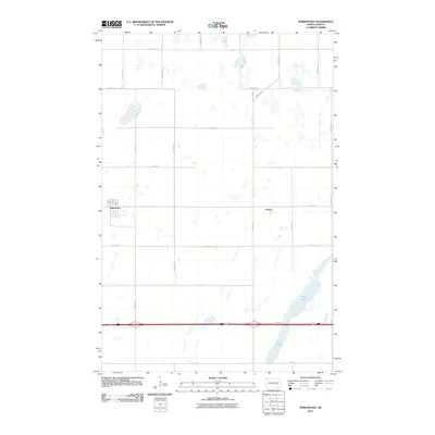
2011 Map of Spiritwood
USGS Topo · Published 2011About this map
Spiritwood and the smaller settlement of Urbana anchor this section of the North Dakota plains, characterized by a complex network of glacial prairie potholes and larger water bodies. The landscape is defined by its rectilinear section-line grid, where roads like 95th Ave SE and 30th St SE facilitate transport between dispersed agricultural operations. In the southeastern portion of the quadrangle, Island Lake and Goose Lake break the regularity of the terrain, providing significant hydrological landmarks amidst the smaller wetlands that dot the region. The map captures the infrastructure of rural Stutsman County in the early 21st century, showing how modern corridors like County Hwy 3 integrate with local village streets such as 1st St N. This survey provides a precise record of the prairie landscape before continued land-use changes or hydrologic shifts potentially alter the visibility of these distinct prairie potholes.
Find a feature on this map
24 named features on this map. Tap any name to fly to it.
Don’t see what you’re looking for? This feature index may not catch every label — zoom into the map to look around manually.
Map Details
Editions of this 2011 Spiritwood Map
This is the sole edition of this map. No revisions or reprints were ever made.
Other maps of this area

1896 · Jamestown
USGS Topo · 1:125,000

1897 · Eckelson
USGS Topo · 1:125,000

1900 · Pingree
USGS Topo · 1:125,000

1951 · Spiritwood Lake
USGS Topo · 1:24,000

1952 · Ypsilanti
USGS Topo · 1:24,000

1952 · Bloom
USGS Topo · 1:24,000

1952 · New Rockford
USGS Topo · 1:250,000

1953 · Jamestown
USGS Topo · 1:250,000

1956 · New Rockford
USGS Topo · 1:250,000

1956 · Jamestown
USGS Topo · 1:250,000