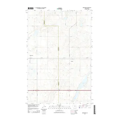
2014 Map of Spiritwood
USGS Topo · Published 2014About this map
Spiritwood and the smaller settlement of Urbana anchor this landscape along the eastern edge of Stutsman County. The map documents a classic North Dakota prairie environment, where the land is strictly organized by a regular grid of section roads including Haxtun Ave S and various numbered streets. This rigid survey pattern is frequently interrupted by the natural depressions of the Prairie Pothole Region, most notably Rush Island Lake, Island Lake, and Goose Lake. The boundary between Stutsman Co and Barnes Co runs vertically through the center of the sheet, illustrating how political lines often bisect these agricultural expanses. This 2014 edition captures the modern infrastructure of the region, showing how Interstate 94 cuts an east-west path across the southern portion of the quadrangle, facilitating transport between the rural townships.
Find a feature on this map
20 named features on this map. Tap any name to fly to it.
Don’t see what you’re looking for? This feature index may not catch every label — zoom into the map to look around manually.
Map Details
Editions of this 2014 Spiritwood Map
This is the sole edition of this map. No revisions or reprints were ever made.
Other maps of this area

1896 · Jamestown
USGS Topo · 1:125,000

1897 · Eckelson
USGS Topo · 1:125,000

1900 · Pingree
USGS Topo · 1:125,000

1951 · Spiritwood Lake
USGS Topo · 1:24,000

1952 · Ypsilanti
USGS Topo · 1:24,000

1952 · Bloom
USGS Topo · 1:24,000

1952 · New Rockford
USGS Topo · 1:250,000

1953 · Jamestown
USGS Topo · 1:250,000

1956 · New Rockford
USGS Topo · 1:250,000

1956 · Jamestown
USGS Topo · 1:250,000